
Table of Contents
Introduction to Udayapur district:
Udayapur District, located in Koshi Province, Eastern Nepal, boasts a diverse geography with rivers, hills, and wildlife reserves. Its history includes the ancient Chaudandi Kingdom. The district’s administrative shift to Gaighat in 1972 marked its modern development. Udayapur features Mahabharat Hills, Churiya Hills, and the Inner Terai region. With a population of 317,532 in 2011, the district is ethnically and linguistically diverse, reflecting Nepal’s rich cultural tapestry. Notable places include Tribeni, Rauta, Koshi Tappu, and Chaudandigadhi Durbar. Udayapur is connected by highways, contributing to its accessibility and transportation infrastructure.
Geography of Udayapur:
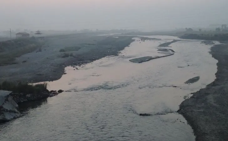
Udayapur is characterized by rivers and hills, with natural borders formed by the Koshi River to the east, Sun Kosi River to the north, Tawa Khola to the west, and Siwalik foothills to the south. The Koshi Tappu Wildlife Reserve lies to the east, spanning Udayapur, Sunsari, and Saptari Districts.
History:
Before the unification of modern Nepal by the Shah kings, Udayapur District was under the Sen dynasty, with the Kingdom named Chaudandi. The capital of the kingdom was Chaudandigadhi.
Administrative Changes:
Before 1972, Panchawati was the headquarters of Udayapur District, later moved to Gaighat in 1972. Udayapur District was part of the Eastern Development Region in the Sagarmatha Zone based on the former administrative divisions of Nepal.
Geography and Climate:
Udayapur Valley, about 30 km long and 2 to 4 km wide, is drained by the Triyuga River flowing east to join the Koshi River. Forest cover constitutes 67% of the total land area, while 28% is cultivated land. The district has a variety of rivers, including Triyuga, Tawa Khola, Vaidyanath River, Kakaru Khola, and others.
Physiographic Zones:
Mahabharat Hills, Churiya Hills, and the Inner Terai region are the three distinct physiographic zones in the district.
Demographics:
As of the 2011 census, the district had a population of 340,498. The major languages spoken include Nepali, Magar, Tharu, Chamling, Tamang, Maithili, Bantawa, Rai, Danuwar, and others. The major ethnic groups include Chhetri, Rai, Magar, Tharu, Tamang, Hill Brahmin, Kami, Newar, Danuwar, Damai/Dholi, and others. The majority religion is Hinduism, followed by Buddhism, Kirat, Christianity, Islam, and others.
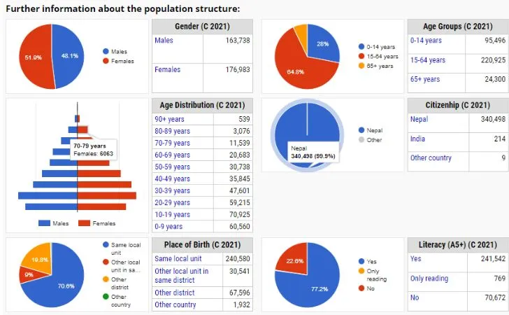
Population Data for Udayapur District, Nepal
- Total Population: 340,498
- Males: 163,738
- Females: 176,983
Age Distribution (Census 2021)
- 90+ years: 539
- 80-89 years: 3,076
- 70-79 years: 11,539
- 60-69 years: 20,683
- 50-59 years: 30,738
- 40-49 years: 35,845
- 30-39 years: 47,601
- 20-29 years: 59,215
- 10-19 years: 70,925
- 0-9 years: 60,560
Place of Birth (Census 2021)
- Same local unit: 240,580
- Another local unit in the same district: 30,541
- Other district: 67,596
- Other country: 1,932
Age Groups (Census 2021)
- 0-14 years: 95,496
- 15-64 years: 220,925
- 65+ years: 24,300
Citizenship (Census 2021)
- Nepal: 340,498
- India: 214
- Other country: 9
Literacy (A5+) (Census 2021)
- Yes: 241,542
- Only reading: 769
- No: 70,672
Administration:
Udayapur District is administered by Udayapur District Coordination Committee (Udayapur DCC). The district is divided into various municipalities and gaunpalikas after the nullification of VDCs in 2017.
Constituencies:
Udayapur District is divided into parliamentary and provincial constituencies, each represented by elected members. Here’s the information about the constituencies in Udayapur District, Nepal, along with their respective representatives:
Udayapur 1 (Parliamentary Constituency)
- Incorporated Areas: Triyuga, Chaudandigadhi, Belaka
- MP/MLA: Narayan Khadka
- Party: Nepali Congress
Udayapur 2 (Parliamentary Constituency)
- Incorporated Areas: Katari, Udayapurgadhi, Rautamai, Tapli, Limchungbung
- MP/MLA: Suresh Kumar Rai
- Party: Nepal Communist Party
Udayapur 1 (A) (Provincial Constituency)
- Incorporated Areas: Chaudandigadhi, Belaka
- MP/MLA: Bimal Karki
- Party: Nepal Communist Party
Udayapur 1 (B) (Provincial Constituency)
- Incorporated Areas: Triyuga
- MP/MLA: Himal Karki
- Party: Nepali Congress
Udayapur 2 (A) (Provincial Constituency)
- Incorporated Areas: Udayapurgadhi, Rautamai, Limchungbung
- MP/MLA: Narayan Bahadur Magar
- Party: Independent
Udayapur 2 (B) (Provincial Constituency)
- Incorporated Areas: Katari, Tapli
- MP/MLA: Kala Ghale
- Party: Nepal Communist Party
Transportation:
Gaighat, the district headquarters, is connected to the national highway system, including Sagarmatha Highway (NH-16) and Madan Bhandari Highway (NH-09).
Interesting Places:
Tribeni, a confluence of three rivers, Kamla, Tawa, and Dudhauli, is popular. Rauta, a holy place for Hindus in Rautamai rural municipality, has a temple of Mahadev and a pond called Rauta Pokhari. Koshi Tappu, a protected wildlife area, is located near the Koshi River in the southeastern part of Udayapur. Chaudandigadhi Durbar, the fort’s remains of Sen Kingdom, can be seen in Chaudandi.
Conclusion
Udayapur: Diverse geography, rich history, and cultural vibrancy in Eastern Nepal. From the ancient Chaudandi Kingdom to modern Gaighat, it features picturesque hills, a population of over 300,000, and notable places like Tribeni and Koshi Tappu. Governed by the Udayapur District Coordination Committee, it’s easily accessible via highways Sagarmatha and Madan Bhandari—a unique blend of tradition and modernity.